Rae Lakes Loop 2024

The Rae Lakes Loop hike is a coveted and iconic hike that I had wanted to tackle for some time. In several seasons, there were road closures due to storm damage, or wildfires. Finally the road and trails were open and I was able to get a permit for late September of 2024. Once again, I purposely allowed myself four nights for a leisurely pace, as I knew I wanted to take photos and spend extra time enjoying the surroundings, plus avoid having to drive home late at night. The Rae Lakes loop is considered somewhat challenging due to elevation changes, and because it is a very popular trail that is also part of the Pacific Crest and John Muir trails, it has a quota system that can make getting a permit challenging. I considered myself lucky and was excited to experience the trail. The week’s weather forecast was quite favorable.
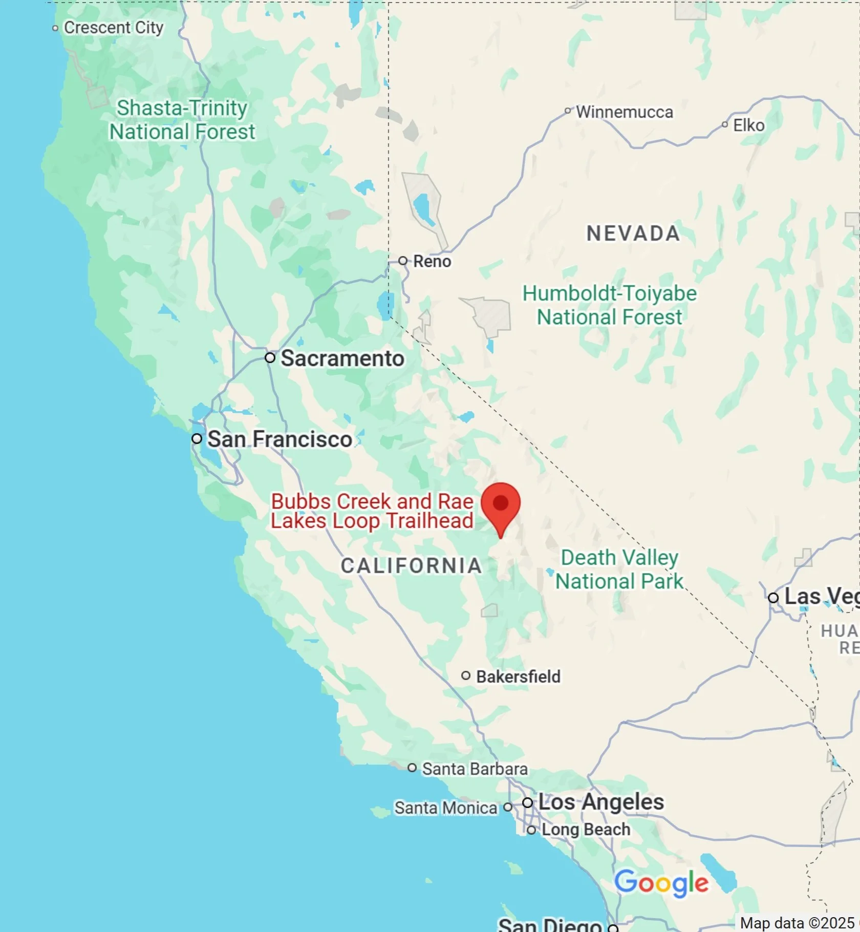
Location (Red icon) of the Rae Lakes Trailhead in Kings Canyon National Park, California

GPS Track of my clockwise Rae Lakes Loop route. Total Distance: 49.5 Miles (79.7 Km)

Above: Elevation Change for Clockwise Route
Arrival in King’s Canyon National Park: Because of the distance from the Bay area, I made reservations months in advance at the Sentinel Campground, which was also quite booked. I actually set up a notification system for an opening there, which I was able to take advantage of. This is a handy feature of Recreation.gov. Arriving late in the afternoon, I simply car camped overnight. This allowed me to head straight to the Ranger station near the trailhead the next morning.


Entry into the park requires an in-person visit at the Ranger station, where they print out a permit with a wire tag for hanging, and provide thorough and careful instructions to each camper. Due to the popularity of the trail, and the wide range of skills of visiting backpackers, they take extra caution in informing visitors of risks: bears, hypothermia (freezing temps at some elevations), sun exposure, dehydration, etc. Bear canisters are required and in some cases they asked to see the canister.
Surprisingly, the ranger said they often conduct more than 3 search and rescues / week, primarily due to ill-prepared hikers!
Day 1: Woods Creek Trailhead to Middle Paradise Valley: 8.4 miles - 13.5 km
After collecting my permit, I started hiking north around 9:15, in a gradual ascent. The trail followed the South Fork of the Kings River, offering spots to stop for water and enjoy the view along the way. The morning air was cool, perfect for a light long-sleeve shirt, but it warmed up after I passed Mist Falls.


I arrived at my intended camp of Middle Paradise in the early afternoon, with plenty of time to set up camp, filter water, take photos and cool off after the warm hike. My pack felt a bit heavier than usual with 4.5 days of food in a Bear Vault 450. There were two other groups of hikers by evening, with plenty of space between sites. I chose to stay on the west side of the trail, further from the river, and the site had two bear lockers.


Day 2: Middle Paradise Camp to Woods Creek Crossing: 9.1 miles - 14.6 km
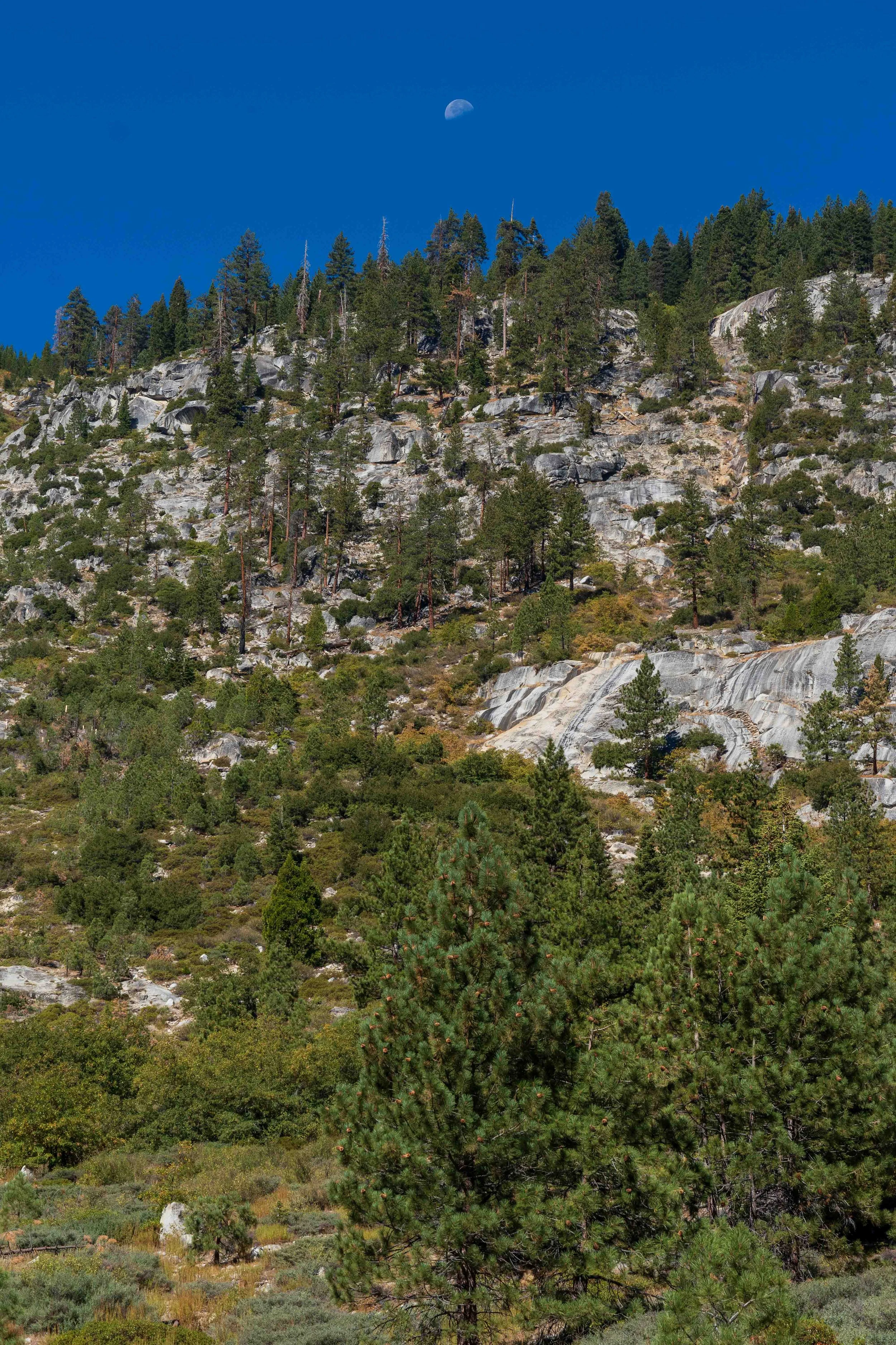
In the morning, I packed up unhurriedly and headed north to Upper Paradise Camp. This was clearly the best of the Paradise Camps, with some nice private sites and the gentle noise of the river more prevalent. As I was hiking solo, I made the conservative choice to wade across the river rather than rock hop. Looking back to the west, I loved the view of the moon over the mountains.
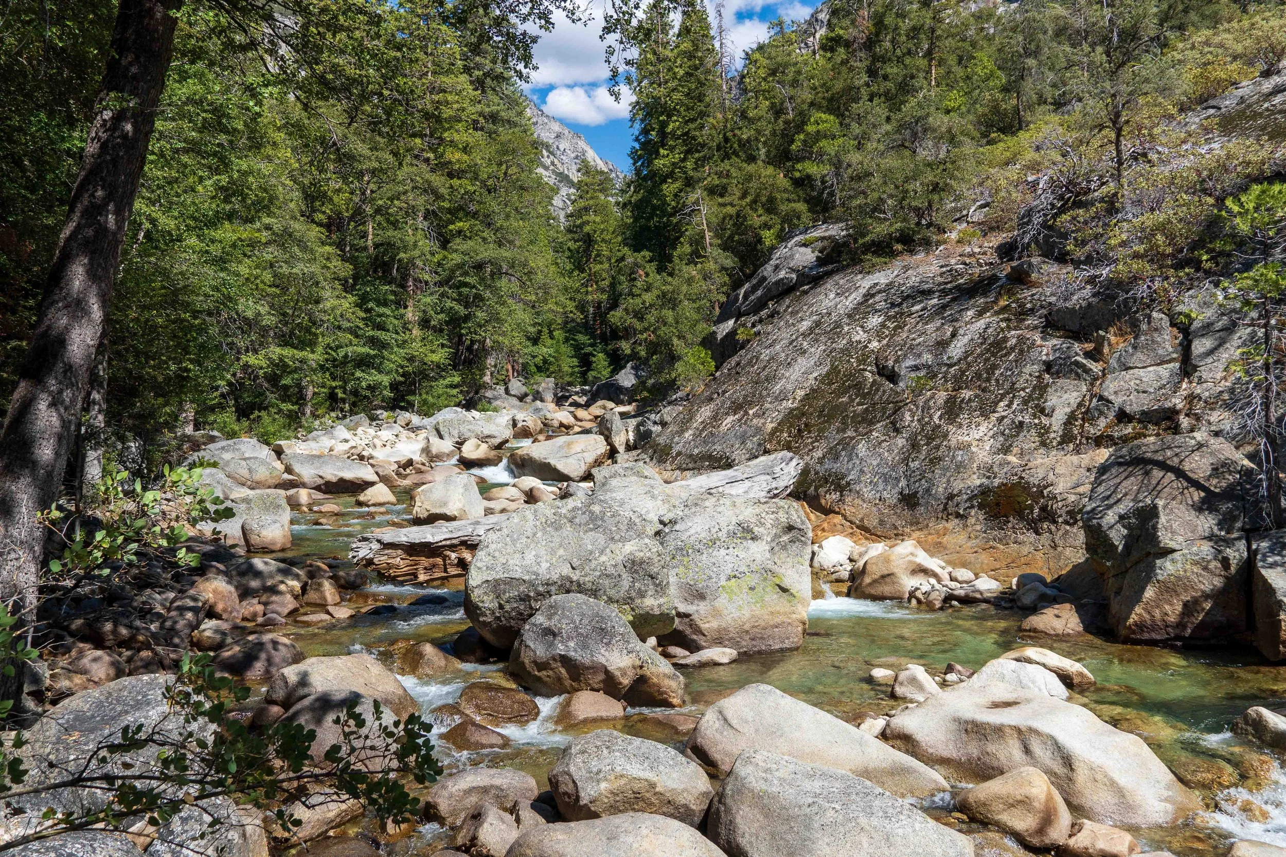
Most of the hike was a gradual ascent to the east of more than 2600 ft, following Woods Creek. There were less occasions to see the creek, as it was often below the trail or a hundred feet away. I stopped at one of the side trails to the creek for lunch and more water. It was a warm day, and somewhat more exposed and less scenic than the previous day, so it seemed like a long trek before I finally hit some shade. I was delighted to see a few quaking aspens along the trail, and finally arrived at the Woods Creek Crossing camp. This was a busy camp, likely because it intersected with the Pacific Crest and John Muir trails, and there were a few through-hikers. There were plenty of tent sites though, and I found a nice private spot further from the creek but with a bit of shade.


Day 3: Woods Creek to Middle Rae Lake: 7.3 miles - 11.7 km Unlike all the through-hikers, I had a leisurely start to my morning, taking pictures of the bridge over Woods Creek before continuing my ascent, now mostly to the south. Just before I set off, I came across the ranger from Rae Lakes, who was departing for the season. She asked if I would drop off a leather log journal at the ranger’s cabin, and I happily obliged. She was headed out of the park completely, so had a much longer journey than I did. When I indicated I was impressed at her putting in all that mileage, she laughed and indicated it was all downhill. Still, her pack seemed to be heavily laden. The rangers work hard! She said the hills ahead of me were full of fall colors and were gorgeous, and she was right. This was one of the most scenic and enjoyable backpacking days ever!
Southeast Section of Rae Lakes Loop Slideshow


The weather felt perfect as I made my way south on a gentle climb toward Dollar Lake, where I stopped to refill my water bottle and have a relaxing lunch. I had Dollar Lake all to myself, before continuing south to Arrowhead Lake, which also seemed deserted. A short while later I came upon Lower Rae Lakes, where I saw perhaps one small camping group, and arrived at Middle Rae Lake. After taking a side trail to find the Ranger’s cabin and leave the notebook, I headed back to the trail to check out the sites. I wanted to see if I could find a spot that overlooked the lake, so I could capture some more night sky photos. At the same time, it was lower elevation and colder by the lake, so I puttered around and debated a bit, before finally settling into a spot higher on the hill that offered both privacy and less wind. There were quite a few tent sites at Middle Rae, fairly well separated from each other, but many of the best sites were already taken. Some folks seemed to be camped out for a couple days, against the regulations. After setting up my tent, I headed to the lake to gather and filter my water, and I found a flat rock overlooking the lake that was away from other tent sites. I warned the group of women nearest me that I might be walking around a bit after dark for night sky photography, but I would do my best to be quiet and not trouble them. As it turned out, it was dark when I returned from my photography venture, and one kind woman pointed me to the correct side trail back to my tent when I headed in the wrong direction. I finished my photography by 9 pm or so, but slept poorly and was shivering a bit during the night; it was colder at this higher elevation of over 10,500 ft.

Day 4: Middle Rae Lakes over Glenn Pass to Bubbs Creek: 7.1 miles - 11.4 km
I was up fairly early the next morning, and a small herd of deer were right outside my tent. The through-hikers were already on the trail while I was still struggling to find a private bathroom location. This is a big disadvantage of this site more than others: there are few appropriate bathroom locations far enough from the trail and campsites without hiking quite a way from camp.
It was cool when I headed out in the morning past Upper Rae Lakes, but I was quickly shedding layers as I began my slow climb to the top of 12,000 feet Glenn Pass. The trail wasn’t particularly steep, and I began to pass more clumps of ice and snow as I gained elevation. I was passed by younger hikers a few minutes before the pass, but when I arrived at the top we all enjoyed the stupendous view and relished the sense of accomplishment. It was cool and windy at the pass, so I didn’t linger, knowing I had a long descent to my next campsite at Lake Reflection Junction.
Middle and Upper Rae Lakes


Views from the Top of Glen Pass


On the south side of the pass, there was one sketchy area where I may have missed the correct trail, and had to slide down a steep section on my back and butt. Subsequently, the trail was rocky and barren, but with switchbacks it was an easy descent down to an alpine lake, and ultimately reaching the treeline. The day warmed up nicely, but there was no water at the campsites at Glenn Pass or at Onion Valley Junction. Finally I reached a small creek at an intersection with Bullfrog Creek Trail, and it was quite busy with hikers all stopping to rest, gather more water, and re-hydrate. I met a nice, young couple I had shared the Glenn Pass view with, and we compared notes on shared adventures and I inquired about their Six Moon Designs sun umbrella hats.


With lunch and a rest in the shade, I resumed my descent and was tired by the time I reached the East Lake trail junction around 5 pm. The forested area was darker and cooler, but with few sites. Two fellows were in a spacious site with a campfire already underway, so I scouted around further in the woods to find an older site that offered privacy and sufficient distance from the guys. After clearing the brush and deadfall around the site, I set up my tent and had some dinner before retiring to my tent around 7:30. The night was much warmer at this lower elevation!
Around 2:30 in the morning, after a bio-break, I didn’t fall back asleep right away, so switched on my Kindle to read myself to sleep. All of a sudden, I felt something bump hard into my tent side, right near my head. I knew it wasn’t a bird, and not large enough to be a bear or a deer. Startled, I sat up momentarily. I then felt another swipe, pushing hard against the side of the tent. This was definitely a mid-sized animal hitting my tent! I called out “Hey” loudly, but didn’t see anything when I unzipped my tent flap and peered outside less than a minute later. I realized as I settled back down that the behavior was consistent with a curious animal swiping at the light of my Kindle, and that it could have been a raccoon, bobcat, or mountain lion. I began to consider the value of camping under a tarp instead of a closed tent, so I could be more aware of the wildlife around me.
Day 5: East Lake Trail Junction to Trailhead: 10.9 miles - 17.6 km
I was on the trail before 8:30 am., preparing for the long but easy hike out to the trailhead. On the flat trail, with an empty bear canister and a cool morning, I made good time initially, but began to slow a bit after mile 7. After lunch at Bubbs Creek West, I began the hot, dry descent through 18 switchbacks onto the forest floor and across two bridges. At the last bridge I again met the nice couple Nick and Mary, who asked me to take their photo. Nick offered me a sample of his artwork derived from topo maps, and I offered them any of my Milky Way shots if they turned out decent. We traded notes on recommended backpacking outings, and I hoofed the last two miles down the wide trail back to my car. After the 11 mile hike out, I was hot and tired, but thrilled to have finally experienced this unique and glorious backpacking route.


This was an epic backpacking trip of a lifetime, and a must-do for backpackers from all over. I highly recommend this trip, but encourage folks to take the extra nights to fully enjoy the experience. Don’t make it a ‘death march’ as many folks do. Late September was a good time to visit in spite of the cool nights at higher elevations. The fall colors were spectacular and the crowds may have been smaller, (although I think Rae Lakes will be filled to its quota any time except winter). The trails are all well maintained, and you’ll know you completed an epic hike when you’re finished. Don't miss this one!
Photos by Cris Lewis; Sony Alpha 6600, 18-135 mm Sony lens, 15 mm f1.4 Sony G lens
LOGISTICS
Wilderness Permit reservations for SEKI are available 6 months in advance, or up to 7 days in advance where openings exist. Permits for the Rae Lakes loop are hard to get, so plan early.
Bear-proof containers are absolutely required, and although there were signs posted for bear warnings, I didn’t see one on the entire trip. The trails were all in excellent shape and well-maintained.
In spite of icons on different maps showing latrines, there were none on the entire trip. At Middle Paradise Camp, there was still a sign on the trail pointing to a latrine, but it was broken down. There was not a latrine that I found at Rae Lakes either, which I felt was desperately in need of one. Be sure to wander far from the campsites and practice leave no trace principles, including packing out toilet paper. (I use a long plastic bag that is used for newspaper delivery.)